
Observing a critical part of the Atlantic Ocean to better understand our climate
To improve future climate models, researchers from the University of Gothenburg are now making the first measurements of the fine-scale ocean currents in a region of the South-East Atlantic known as the Cape Cauldron.
“It’s a critical part of the world ocean, where warm, salty water from the Indian Ocean escapes into the Atlantic, ultimately affecting our climate and weather in Europe,” says Sebastiaan Swart, Professor of Oceanography at the Department of Marine Sciences, University of Gothenburg.
The South-East Atlantic Ocean has an enormous importance on the Earth's weather and climate. The region is where the Indian, Atlantic, and the Southern Ocean meet, and where currents meet and mix different waters that ultimately have consequences for the circulation of the Atlantic Ocean and the regulation of the global climate. That’s because these local currents form part of the global ocean circulation that transports heat around the globe.
First time measure fine-scale currents
An expedition, including researchers from the University of Gothenburg, is now in the Cape Cauldron region several hundred kilometres southwest of Cape Town, South Africa, to for the first time measure the fine-scale ocean currents 1-10km in size, known as “submesoscale flows”, in order to better understand the mechanisms behind the critical part of ocean interaction known as the “Agulhas leakage”.
It’s in this area that large amounts of warmer and saltier water from the Indian Ocean “leak” into the cooler Atlantic in the form of huge 200km wide ocean vortices to much smaller 10km sized eddies and jets – a flux that later forms part of the Gulf Stream.
“Without this Indian Ocean water, the circulation of the Atlantic Ocean doesn’t close. We expect our new estimates of the Agulhas leakage to improve our knowledge of the circulation of the Atlantic, so we can inform climate models of how the climate may change in the future,” says Estel Font, Oceanography PhD student at the University of Gothenburg.
High resolution views from a new satellite mission
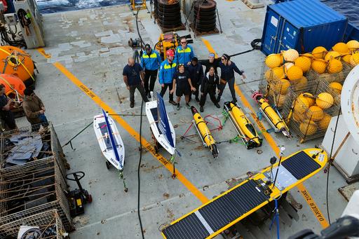
The researchers will be out at sea for a month on the American research vessel, Roger Revelle. During the expedition, they will use underwater gliders and autonomous surface robots to make on-site measurements of, for example, temperature, salinity, oxygen, nutrients, and microscale mixing in the submesoscale flows.
“Four leading oceanographic institutions around the world, including the University of Gothenburg, has kitted this ship with the most modern technologies and sensors available to execute this research. It’s very motivating,” says Johan Edholm, Oceanography PhD student at the University of Gothenburg.
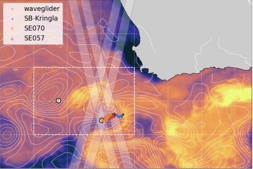
The researchers will also collect crucial data underneath a satellite, recently launched by the space agencies, NASA and CNES (French Space Agency).
“The satellite has just started collecting its first high-resolution measurements of the ocean surface topography – the meter-scale changes in sea surface height that tell scientists about the circulation patterns of the ocean. The sea surface isn’t entirely flat, but has small hills and valleys that resemble the circulation patterns of the ocean. This topography is a key measurement to understand ocean circulation,” says Isabelle Giddy, Postdoctoral Researcher at the University of Gothenburg.
Severe lack of measurements
One of the purposes of the expedition is to make on-site measurements to validate that what the satellite is observing is correct, something that’s called “ground truth”. In this way, the researchers can confirm that the satellite is functioning for future monitoring of the area.
“Our hypothesis is that a large proportion of the Indian Ocean waters that leak into the Atlantic are to be found in smaller submesoscale features, rather than in the larger Agulhas Rings. Observations of these features are lacking, as are estimates of the fluxes they affect. Combining satellite imagery, and on-site measurements, we will see if our hypothesis is correct,” says Sebastiaan Swart.
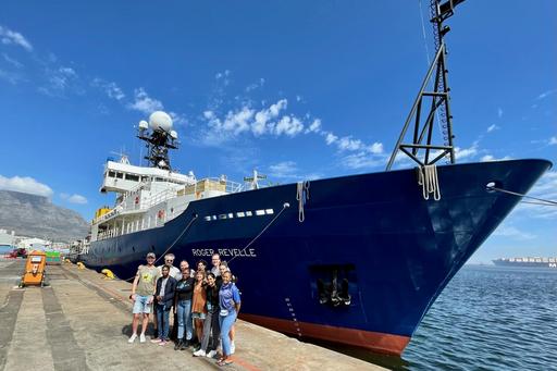
The expedition left Cape Town in early March on the American vessel R/V Roger Revelle.
Participants from the University of Gothenburg: Sebastiaan Swart, Estel Font, Johan Edholm, Sam Fredriksson, Isabelle Giddy, and Michaela Edwinson (master's student). Collaborators at the University of Gothenburg: Bastien Queste, Marcel du Plessis, Theo Spira, Louise Biddle.
External collaborators: Sarah Nicholson at SOCCO-CSIR, and Andre Hoek at Sea Technology Services, South Africa.
The expedition is part of the US-funded project QUICCHE, in which four universities participate: University of Gothenburg, Bangor University, Wales, University of Miami, USA, University of Rhode Island, USA.
More information
QUICCHE website, Polar Gliders research group, Twitter: @PolarGliders, SWOT satellite.
Live data being collected at sea: https://obs.polargliders.com


