UrbTWin – Urban air Temperature and Wind speed variability: Empirical modeling to improve planning applications
Short description
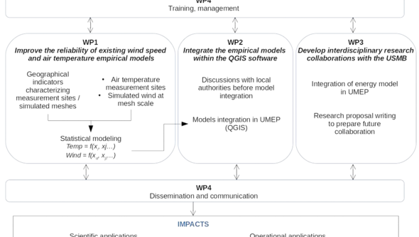
The overall goal of UrbTWin is to determine the urban fabric characteristics (mainly the morphology, vegetation cover and land-type) affecting the air temperature and the wind speed spatial variability. This new knowledge will be integrated in the Geographical Information System software QGIS in order to make it easily available to researchers working with urban issues as well as urban planners. First, empirical models will be developed to relate observed air temperature and simulated wind speed values to geographical indicators characterizing an observed or a simulated location (e.g. distance to building facade, vegetation or building density, etc.). Second, these models will be integrated in the QGIS software and thus will be available for interdisciplinary research purposes.
About the Project
UrbTWin has been proposed to continue researches which have been previously engaged by the University of Gothenburg (concerning wind speed) and by Jérémy Bernard (concerning air temperature).
Wind speed
There is a critical lack of low-computation methods to estimate wind speed spatial variability within urban areas. A first attempt has been initiated by Johansson et al. (2016): empirical models have been established between the wind speed at a given point of the urban environment and geographical spatial indices. The results were encouraging since the empirical model could explain 90 % of the variations of pedestrian wind patterns. However, there were a number of reasons to be cautious about the results.
Air temperature
Numerous empirical models have been proposed by researchers to estimate the air temperature spatial variability (Chen et al., 2012; Steeneveld et al., 2014; Gál et al., 2009). One of their main limitations is that they are valid only for specific weather conditions (often low wind speed and low nebulosity values). Bernard et al. (2017) proposed a new modeling method to extend their validity to all meteorological conditions. The results were very encouraging but the reliability of the model should be improved in order to be used for any city.
For both wind speed and air temperature, several improvements will be proposed in UrbTWin to make the wind speed and air temperature estimations more reliable.
References
Bernard, J., Musy, M., Calmet, I., Bocher, E. & Kéravec, P. Urban heat island temporal and spatial variations: Empirical modeling from geographical and meteorological data. Building and Environment 125, 423–438 (2017).
Chen, L. et al. Sky view factor analysis of street canyons and its implications for daytime intra-urban air temperature differentials in high-rise, high-density urban areas of Hong Kong: a GIS-based simulation approach. International Journal of Climatology 32, 121–136 (2012).
Gál, T., Lindberg, F. & Unger, J. Computing continuous sky view factors using 3D urban raster and vector databases: comparison and application to urban climate. Theoretical and applied climatology 95, 111–123 (2009)
Johansson, L., Onomura, S., Lindberg, F. & Seaquist, J. Towards the modelling of pedestrian wind speed using high-resolution digital surface models and statistical methods. Theor Appl Climatol 124, 189–203 (2016).
Steeneveld, G. J., Koopmans, S., Heusinkveld, B. G. & Theeuwes, N. E. Refreshing the role of open water surfaces on mitigating the maximum urban heat island effect. Landscape and Urban Planning 121, 92–96 (2014)
